Monthly Archives: December 2016

Cold, Snowy First Half of December

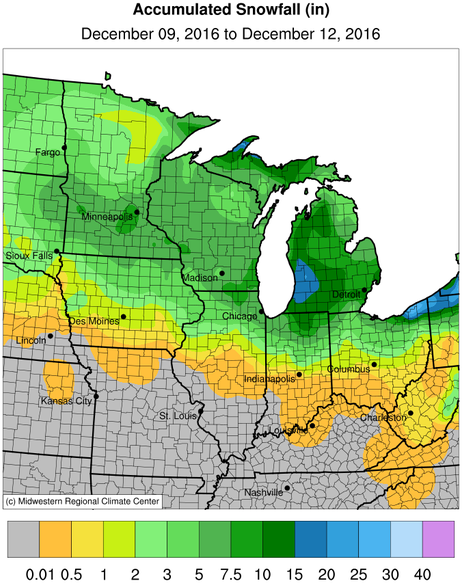
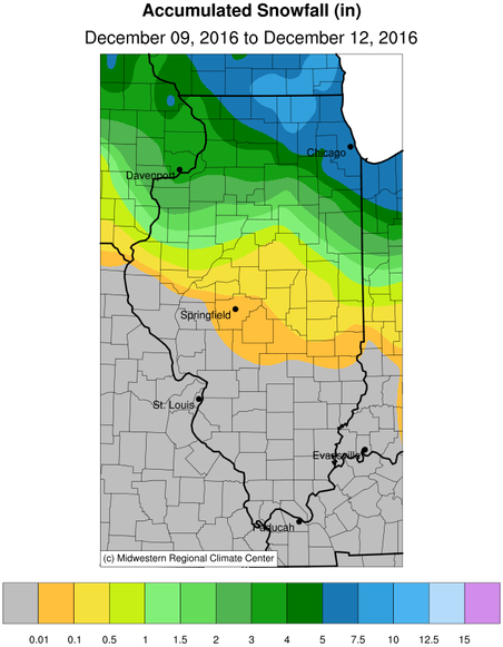
The statewide average temperature for the first half of December is 27.9 degrees, 4.7 degrees above normal. Snowfall (maps below) has been heaviest north of Interstate 80, ranging from 10 to 15 in many locations. The snowfall totals taper off southward, dropping to about 2 inches near Interstate 72, and down to zero inches near Interstate 70 and sites to the south. For many areas in northern Illinois, this represents above-normal snowfall.

More wintery weather is expected today and tomorrow as another winter storm moves through the Midwest. This will be followed by very cold temperatures on Sunday and Monday before moderating somewhat on Tuesday.


Latest Round of Snowfall in Illinois

Just a quick note showing how the recent winter storm played out. The snow was widespread across the upper Midwest, including northern Illinois. Amounts of 5 to 10 inches were common in northeast Illinois. Two sites in McHenry County had over 10 inches of snow: Harvard (IL-MCH-66) with 11.7 inches and Bull Valley (IL-MCH-13) with 10.8 inches. Central and southern Illinois were warmer and received mostly rain instead of snow. Rainfall amount in southern Illinois were in the neighborhood of 0.5 to 0.75 inches.

snow-mw

snow-il

New Outlook for December – Wetter, Colder in Illinois

The NWS released their latest outlook for December. They have Illinois with equal chances (EC) of above, below, and near-normal temperatures for the entire month. However, the day to day forecasts out to 14 days show Illinois having colder than normal temperatures on most of the days. The NWS product for weeks 3 and 4 suggest that warmer-than-normal weather will return in the second half of December. In general, I have higher confidence in the forecasts out to 14 days.

The December outlook also shows Illinois with an increased chance of being wetter than normal. This is true in the shorter range forecasts out to 14 days as well. Considering it’s December, a forecast of colder and wetter than normal conditions sure sounds like a recipe for snow. As you may recall, last December was notable for having almost no snow.

Click to enlarge.

5th Warmest November, 2nd Warmest Fall in Illinois

Temperature

This was the 5th warmest November on record for Illinois, based on preliminary data. The statewide average temperature was 47.4 degrees, and 4.9 degrees above normal. Here are the top ten warmest Novembers in Illinois since 1895:

  1. 2001 with 49.9°F
  2. 1931 with 49.1°F
  3. 1909 with 48.8°F
  4. 1999 with 48.4°F
  5. 2016 with 47.4°F 
  6. 2009 with 47.2°F
  7. 1902 with 46.9°F
  8. 1990 with 46.8°F
  9. 2015 with 46.6°F
  10. 1913 with 46.4°F

It was also the 2nd warmest fall on record for Illinois. The statewide average temperature for fall was 59.4 degrees, 5 degrees above normal. Only the fall of 1931 was warmer at 59.8 degrees. The climatological fall months are September, October, and November.

Precipitation

Continue reading