Monthly Archives: August 2013

Moderate Drought in Western Illinois

Yesterday, the US Drought Monitor has introduced “moderate drought” into far western Illinois. Most droughts move slow and take 3-6 months to develop. However, sometimes they can move very fast if conditions are right, leading to the term “flash drought”. This situation appears to be developing in parts of western Illinois now.

We have the two necessary ingredients in place for a flash drought. One was the exceptionally dry weather over the last 60 days. The other was the warmer than average temperatures over the last two weeks, which drove up the water use by crops. See the previous post on this.

The timing was bad for both corn and soybeans.  Earlier this week, the USDA NASS report for Illinois indicated that 13% of the corn was rated poor to very poor, and that 12% of the soybeans were rated poor to very poor. In a trip to Springfield yesterday, I would say that the quality of the corn ranged widely within the same fields. Corn planted in the low spots was in bad shape due to poor root development, but looked better in the well-drained areas.

Flash droughts are harder to identify and monitor because our usual drought-monitoring tools move too slowly to pick the rapidly-changing conditions. The impacts are usually confined to agriculture in flash drought. Most stream flows, lake levels, and ground water levels have not been impacted by these conditions so far.

il_dm

Hot and Dry across Illinois

I just returned from a morning at the Farm Progress Show in Decatur, IL. I am always amazed at the advances in agriculture since the days of my grandparent’s farm. But it was a very warm and dusty adventure.

Big changes have come to the Midwest over the last 30 days. After a wet spring, and cool June and July, the hot, dry weather has arrived. The first map shows the observed precipitation in the last 30 days. Southern Missouri, far southern Illinois, and Kentucky have received 4 or more inches of rain. Meanwhile large swaths of the Midwest have received less than 2 inches. Some areas in Illinois have had less than an inch.

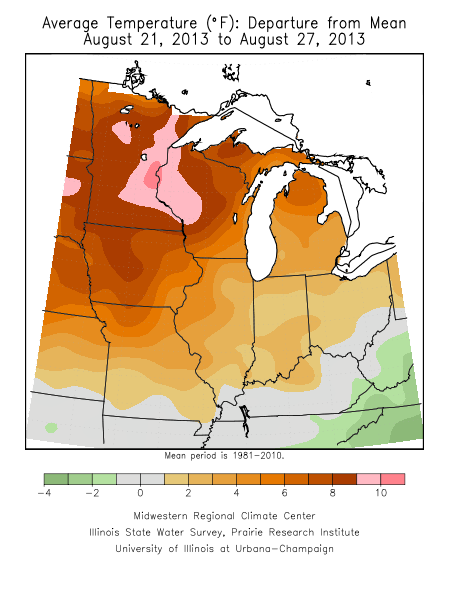
In the last week, hot weather arrived as well. It is a mixed blessing. While it may speed up crop development, it also speeds up the demand on dwindling soil moisture by corn and soybeans. The second map shows the average temperature departures across the Midwest. Illinois is running 1 to 5 degrees above average with the departures increasing northward. In fact, the worst of the heat, in terms of departures from average, is in Iowa, Minnesota, Wisconsin, and the Dakotas.

Maps of the Midwest are found at the Midwestern Regional Climate Center’s Climate Watch.

30-day precipitation across the Midwest, courtesy of the Midwestern Regional Climate Center.

30-day precipitation across the Midwest, courtesy of the Midwestern Regional Climate Center.

tav7dydev

Rain in Parts of Illinois, Finally

Some parts of Illinois received some much-needed rain in the last 24 hours. Here is the combined radar/rain gauge measurements for Illinois. Several places in the northern third of Illinois 1 to 2 inches or more. A few places in south-central Illinois were also lucky. Here in Champaign-Urbana -not so much – with our total of 0.01 inches.

The NWS office in Romeoville posted a radar image and reported rainfall totals.

IL-prcp-mpe-001-tot-20130823

Cool Weather Forces Farm Progress Show to Cancel Field Demonstrations

The Decatur Herald and Review has reported that the Farm Progress Show was forced to cancel their cornfield demonstrations this year because the corn plots are not ready to harvest next week. This was the result of both a wet spring and cool summer.

According to the article it was the first time this has happened in the 60 year history of the show. They use a short-season variety of corn that usually assures that it will be ready to harvest by the show’s start in late August. However the late planting date of May 15 this year and the relatively cool growing season has delayed maturity.

Here are the monthly precipitation and temperatures for this year in Decatur and their departures from average. The numbers tell the story of an extra five inches of rain in April and May and seasonal temperatures almost three degrees below average.

Precipitation:

  • April: 6.74″ (+3.07″)
  • May: 6.78″ (+1.99″)
  • June: 5.22″ (+0.72″)
  • July: 3.56″ (-0.42″)
  • August: 0.09″ (-3.68″) **as of August 22

Temperatures:

  • April: 50.8 (-3.6°)
  • May: 63.9 (-0.3°)
  • June: 71.5 (-1.8°)
  • July: 72.8 (-3.7°)
  • August: 70.8 (-4.3°)

Full story:

http://herald-review.com/news/local/cool-summer-cancels-farm-progress-show-field-demonstrations/article_7c769082-0ae2-11e3-ab98-001a4bcf887a.html

On a side note, I have been attending the Farm Progress show off and on since the 1990s. I look forward to going again this year.

Dryness Continues Across the Corn Belt

What a change in fortunes. After the wettest January-July on record in Illinois with 29 inches and 9.5 inches above average, we are now facing exceptionally dry conditions in the last 30-45 days across much of Illinois as well as the Corn Belt.

As the map of precipitation percent of average since July 1 shows, a large part of the Corn Belt is running at less than 50% (shaded dark orange to red).  Until recently we saw few impacts on crops because of cooler-than-average temperatures and the excess of soil moisture at the beginning of July. But all that is beginning to change. Warmer weather has returned this week and is expected to continue for at least the next 14 days, according to the NWS.

The soil moisture reports from the USDA NASS indicate that soil moisture is beginning to run low. Topsoil moisture a month ago was rated at 16 percent short and 0 percent very short. Monday’s report rated it at 50 percent short and 11 percent very short.

Subsoil moisture a month ago was rated at 9 percent short and 0 percent very short. Now it is rated at 35 percent short and 8 percent very short.

The Illinois State Water Survey reported lower soil moisture levels at their sites.

The one bright spot in the forecast is that there is a chance of rain in the next five days (second map). However, the potential amounts are modest. Northeast Illinois could see between 0.5 and 1.0 inches. The rest of the state is more likely to see 0.5 inches or less.  If the forecast holds, parts of Iowa, Minnesota, and Wisconsin could see some relief from the current dry conditions.

image

30-day precipitation percent of average for period ending August 21, 2013, based on radar and rain gauge data. Click to enlarge.

p120i

5-day potential precipitation amounts from the NWS, August 21, 2013. Click to enlarge.