On Sunday, January 26, the Chancellor of the University of Illinois sent an email to students and staff stating that the University would be operating on a normal schedule on Monday. A student petition was quickly created to protest, citing a NWS forecast of air temperatures below zero and strong winds producing wind chill values of -25°F to -35°F “which can cause frostbite within 10-15 minutes of exposure.” This incident has prompted me to make some comments about wind chill and its use.
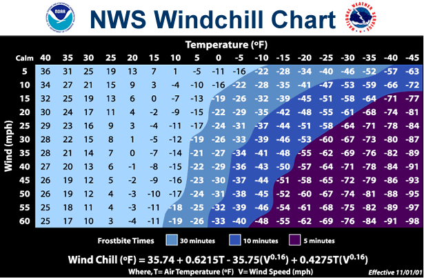
The National Weather Service defines the windchill as
The wind chill temperature is how cold people and animals feel when outside. Windchill is based on the rate of heat loss from exposed skin caused by wind and cold. As the wind increases, it draws heat from the body, driving down skin temperature and eventually the internal body temperature. Therefore, the wind makes it FEEL much colder. If the temperature is 0 degrees Fahrenheit and the wind is blowing at 15 mph, the wind chill is -19 degrees Fahrenheit. At this wind chill temperature, exposed skin can freeze in 30 minutes.
The first research on wind chill was based on how fast water froze in containers in the Arctic in 1939. The formula was revised in 2001 using more advanced models based on human skin.
While the latest version of the wind chill formula is a big improvement over the original, there are some important things to remember when considering wind chill:
- Wind speed is highly variable. The calculations for windchill are based on wind speeds that are usually taken at the airport. While the wind speed is adjusted for the difference between the 33-foot wind instrument to the height of 5 feet, it is still based on winds at the airport in a wide open area. Areas in town with lots of mature trees may have significantly lower wind speeds. Conversely winds between tall buildings in downtown Chicago may be much higher. Therefore, the wind chill at a particular location may be much different from reported at the airport.
- The wind chill formula is based on bare skin of a healthy adult – vulnerability to frost bite or hypothermia can be higher for the elderly and small children. On the other hand, covering bare skin and wearing appropriate clothing greatly reduces the effects of the cold and wind. Sunshine is not included in the formula even though it has the potential to moderate the effects of wind chill during the daylight hours.
- An accurate wind chill forecast requires both an accurate temperature forecast and an accurate wind forecast. Anytime you have to rely on the combined forecast of two separate weather variables, in this case temperature and wind speed, the odds of getting them both right is reduced. For example, despite the forecasted dangerous wind chill values for the Champaign-Urbana campus on Monday, the actual temperatures during the daylight hours on Monday were in the single digits and wind chill values ranged from -17 to -10 degrees. And that was based on wind data from Willard Airport. While it was certainly cold on campus, the sunshine and lower wind speeds made it more bearable.
- Does the wind really make it feel like minus 25? Despite the improved wind chill formula, I am still not convinced that the wind chill is an accurate measure of what the temperature “feels” like. I have experienced wind chill values in the -20 to -30 degree range on several occasions. However, I found that the actual air temperature of -25 degree on the morning of January 5, 1999, to be a far more unpleasant experience than wind chill values in that range.
I appreciate the desire to include more information about severe winter weather by incorporating the effects of low temperature and high winds. Certainly, the hazards of frostbite and hypothermia should be taken seriously. However, anyone using wind chill values to assess the risk of these hazards should consider the limitations described here.